
U N U S U A L P H O T O G R A P H S
|
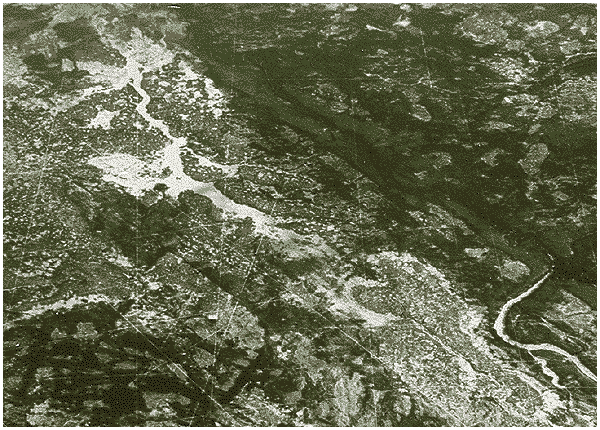
We had several different and wild ideas about the mysterious lines in this photograph, but the serious e-mail we received seems to confirm that this is part of a secret US Navy installation. The following discussion is submitted by Wayne Wenzel and is perhaps the most comprehensive evaluation. Upon confirming the data in Wayne's report, we came across other data related to this military site that was even more disturbing. At a time when the U.S. military is condemning "Weapons of Mass Destruction" (WMD) in countries like Iraq, we learned of an even more deadly weapon that has already been secretly built in Alaska. This weapon is so controversial and powerful that it makes nuclear and biologic warfare as antiquated as clubs and knives. In our next issue we will (hopefully) disclose the details in a special feature, Weapons Of Total Destruction. There were even letters like this:
I'm so glad that someone has obtained photos of these lines - because we've
seen them ourselves from the air.
We vacation in the Canaries every year during December and January. When we
returned to the United States in 1999, instead of flying out toward the
Atlantic, our flight took a northerly route over Scotland and then toward
Greenland, down through eastern Canada toward Chicago. We had never taken
that route before, so we settled in for a long flight. When we were over
eastern Canada our plane took a southerly turn and headed toward Chicago.
Looking down over the land below us I saw these straight lines that went on
for miles. Now, we're at 30,000+ feet and my view was spectacular. Dozens
of these lines appeared below us and continued toward the horizon. There
were also lines that would intersect with these long lines, ad nauseum.
My thought at the time was "what the hell is this?" These lines were part
of the land, they were etched in the ground. I also saw lines that stopped
at the edge of a canyon and continued on the other side. I saw lines that
seemed to end at what seemed to be a river, yet continue on the other side
of that river to the horizon.
The lines that we saw were often very "thick." I would estimate the width
of some of these lines to be near a hundred yards wide, with no apparent
varying thickness as it disappeared into the distance. I also saw, and I
cannot for the life of me figure out how this is possible, that many of
these lines were etched in the land (ground) yet also continued - in a
straight line - onto areas where there was snow. How is this possible?
Although I will eventually find them, I cannot currently find the notes that
I took during that flight. I do know that I consulted the onboard flight
map and was able to approximate where these lines might be located.
Again, thanks for the photo. Our interpretation of the text suggests that
this photo was taken over western Canada. Well, give eastern Canada a try
next time. You'll find them there.
Respectfully,
Hello,
I am commenting on the mysterious lines. First, the ELF is not only used by the military, I am in the mineral exploration business, and we use the same frequency in a survey called VLF, or Very Low Frequency. It uses the ELF/VLF station in Wash. The lines are all over northern North America, from Alaska, the Yukon, Nwt, Nunavut, to Quebec. They are cut lines for geophsical surveys, or for oil/gas exploration. The thin ones are cut using chainsaws, and form a grid pattern, to get a balanced section of land. IP (induced polarization) is one of the surves used on the cut lines, where they lay a few km of wire on the ground, pump electricity into the bedrock and test for ore bodies. When they find an interesting target, they may cut more lines at different angles. The wide lines are often done by bulldozer, and with the help of line cutters (guys with chainsaws). But I am still wondering about that blacked out area on the AK/YT border. It's a no fly zone: we were crossing it with helicopter and were told to go around. Weird...
Cheers,
Viewzone:
The mystery photo of the restricted area of Canada might show the home of the US Navy's project ELF.
ELF stands for Extremely Low Frequency and is a project that the US Navy proposed more than two decades ago. The idea was that a large array of cables, pipes or metal imbedded in the Canadian Shield bedrock could send low-frequency energy waves to nuclear submarines hiding in the deep ocean trenches of the Atlantic and Pacific Oceans. This would allow communication with the subs without requiring them to reveal their positions.
I grew up in Wisconsin, and I remember reading in the news that the Navy's original location of choice for ELF was northern Wisconsin. Cheeseland was a desired location because the bedrock of the Canadian Shield is very accessible there. However, when Wisconsin residents learned of this idea there was a great protest against it. Many feared that ELF would make Wisconsin a primary target in a nuclear conflict. Others disliked the idea of the US government controlling and restricting such a large section of land within the state. There were also environmental and health concerns about the potential effects of low frequency energy waves on humans. Dairy farmers feared cows might sense the energy waves and give less milk. The fact was, nobody really knew what the effects might be, and they didn't want to be the guinea pigs to find out.
There are now ELF transmitters in Wisconsin and Michigan, but their existence continues to be under fire by tax-cutting groups and environmentalists. It still seems quite possible that the mystery photo is an ELF transmitter in Canada, especially considering that the photographer said his plane had been escorted by Navy jets.
Looking at the grid-like patterns in the aerial photo you posted, it immediately struck me that it is quite possible that the US forged a agreement with Canada to install an ELF grid in remote Canada, thereby bypassing the need for approval by US citizens. And what better place to access the Canadian Shield than in Canada?
Here's just one of the articles on the internet that I found:
Proposal & savings:
Shelve the Navy's Extremely Low Frequency Transmitters (Project ELF). Deactivating the system while maintaining
the infrastructure for possible future use is estimated to save the taxpayer $60 million over five years.
Background:
Begun in the mid-1960's as "Project Sanguine," the Navy's Extremely Low Frequency communications project is
designed to signal deeply submerged nuclear-armed Trident submarines in attack situations. Project ELF consists of
two transmitters, one each in Clam Lake, Wisconsin, and Republic, Michigan. At its best, the system transmits a
one-way signal to submerged submarines indicating when they should ascend to receive a more detailed
communication.
Recent Action:
Project ELF has had a couple of close scrapes recently. In the FY95 rescissions bill, the Senate voted
to terminate funding for Project ELF. In rescissions conference, however, funding was restored. During consideration
of the FY96 Defense Appropriations bill, Wisconsin Senators Russ Feingold (D) and Herbert Kohl (D) succeeded in
passing an amendment on the floor of the Senate to terminate Project ELF. However, in the House-Senate conference,
Rep. C.W. Bill Young (R-FL) and Senator Ted Stevens (R-AK) restored funding based on a Navy briefing on the
national security issues surrounding a program known as EHF* (see below) -- not ELF. In FY97, $13 million was appropriated
for Project ELF. In the 1996 court case Wisconsin v. Donna and Tom Howard-Hastings, three expert witnesses --
including former nuclear submarine commander Captain James T. Bush -- were able to establish that Project ELF's
sole role is to launch and wage a nuclear war.
Taxpayer & economic argument:
In the words of Senator Feingold, Project ELF "lingers like a blot in our budget." For nearly two decades Project ELF
has survived. As early as 1979, the General Accounting Office recommended "that the Secretary of Defense terminate
any plans to construct an extremely low frequency transmitter system [since it] enhances communications capability
only marginally at best." The following year the Navy agreed. Secretary of Defense Caspar Weinberger overruled the
Navy in 1981 and the project was allowed to continue.
Environmental argument:
Wisconsin and Michigan residents object to the siting of the ELF transmitters, calling the project a nuisance. Metal
fences in the surrounding area, for example, must be grounded to avoid serious shock from the presence of high
voltages. Several residents claim to hear the "Taos Hum": a low, grumbling noise on the threshold of audibility.
Thousands have participated in demonstrations, petitions, and votes in opposition to Project ELF. Ten editorials have
appeared in Wisconsin and Minnesota papers calling for ELF to close.
Furthermore, local residents and some scientists believe that Electromagnetic Pollution (EMP) has direct and adverse
effects on human health. In 1984, a U.S. District Court ruling on Wisconsin v. Weinberger found enough evidence to
close down Project ELF for possible health effects and for violations of the National Environmental Protection Act.
The ruling was subsequently thrown out based on the relative importance of the perceived Soviet threat. In addition,
more than 40 medical studies point to a link between Electromagnetic Pollution and cancer -- 14 to brain tumors alone
-- and abnormalities have been found in a variety of both animal and plant species.
Contacts:
Mike Miles, Coalition to Stop Project ELF, (715) 472-8721; Bonnie Urfer, Nukewatch, (715) 472-4185; Laura Olah, Citizens for Safe Water Around Badger, (608) 643-3124.
*EHF was a secret program related to our next disclosure, Weapons of Total Destruction.
|
<--table of contents-- || --Unusual Photo-->